Turn on suggestions
Auto-suggest helps you quickly narrow down your search results by suggesting possible matches as you type.
Showing results for
Turn on suggestions
Auto-suggest helps you quickly narrow down your search results by suggesting possible matches as you type.
Showing results for
BIM Coordinator Program (INT) April 22, 2024
Find the next step in your career as a Graphisoft Certified BIM Coordinator!
Collaboration with other software
About model and data exchange with 3rd party solutions: Revit, Solibri, dRofus, Bluebeam, structural analysis solutions, and IFC, BCF and DXF/DWG-based exchange, etc.
- Graphisoft Community (INT)
- :
- Forum
- :
- Collaboration with other software
- :
- Google Earth rotation
Options
- Subscribe to RSS Feed
- Mark Topic as New
- Mark Topic as Read
- Pin this post for me
- Bookmark
- Subscribe to Topic
- Mute
- Printer Friendly Page
Google Earth rotation
Anonymous
Not applicable
Options
- Mark as New
- Bookmark
- Subscribe
- Mute
- Subscribe to RSS Feed
- Permalink
- Report Inappropriate Content
2007-08-01 04:18 PM
I have imported the kmz file with the origin of the project, and when i try to import a snapshot of google earth it is positioned on the right origin and the north rotated upside. I would like to have the north rotaded like the north that i set in the 3d window for the sunlight evalution, and for an easier way to draw. I've rotaded the bitmap and the terrain to the true angle and it's all in archicad 11 but when i try to export the 3d into google earth it is wrong rotaded, like if it isnt able to know that the terrain, the object (origin imported from GE), and the bitmap was rotated.
Anyone know how to rotate the origin of the GE object or what is wrong in my proceeding?
Thanks and sorry for my english
Labels:
- Labels:
-
Data Exchange
8 REPLIES 8
Options
- Mark as New
- Bookmark
- Subscribe
- Mute
- Subscribe to RSS Feed
- Permalink
- Report Inappropriate Content
2007-08-01 06:29 PM
Are you sure that your project north is the actual geographical north?
Djordje
ArchiCAD since 4.55 ... 1995
HP Omen
ArchiCAD since 4.55 ... 1995
HP Omen
Anonymous
Not applicable
Options
- Mark as New
- Bookmark
- Subscribe
- Mute
- Subscribe to RSS Feed
- Permalink
- Report Inappropriate Content
2007-08-01 07:06 PM
Yes I'm pretty sure. How you can see in the attached picture the object "North" in the top-right is setted up with "follow the project North", but the GE positioned with "Position Google Earth picture" keep to point upside...
I've try to rotate also the project origin, or the object "GEPlacemark" but it's continue to point upside everytime

I've try to rotate also the project origin, or the object "GEPlacemark" but it's continue to point upside everytime
Anonymous
Not applicable
Options
- Mark as New
- Bookmark
- Subscribe
- Mute
- Subscribe to RSS Feed
- Permalink
- Report Inappropriate Content
2007-08-23 10:12 AM
Having just been trying to export an AC11 model into Google Earth, I hit the same problem.
Seems you can't just orientate the model and terrain by rotation of the photo-download.
I ended up having to make a separate file of the building, then turning it from it's normal orthogonal view, to get its effective North Point at top dead centre, THEN, taking the Google Snapshot. This at least got the orientation right.
However, the centring is still very hit and miss, there is a distinct variance between the logical origin (0,0,0) and what Google Earth regards as the origin, which seems to be the centre of the screen display. Yes it can be shuffled around till it fits but when there is a real world setting out point as the origin, seems daft that you can't just use it.
SO>>> Suggestion to GS.
Adjust the AC/GE interface to achieve two objectives.
1/ Just import a screen shot and rotate that to fit the building model (not the other way around) and get the software to feed back the twist to GE or 3D Warehouse for correct real world orientation.
2/ Set the location pin as EITHER, mid screen (as is now and probably adequate for most situations) OR, true Zero Origin, which can be tagged onto a real world object in the screen shot.
Options
- Mark as New
- Bookmark
- Subscribe
- Mute
- Subscribe to RSS Feed
- Permalink
- Report Inappropriate Content
2007-08-23 06:54 PM
Granville wrote:
Adjust the AC/GE interface to achieve two objectives.
1/ Just import a screen shot and rotate that to fit the building model (not the other way around) and get the software to feed back the twist to GE or 3D Warehouse for correct real world orientation.
2/ Set the location pin as EITHER, mid screen (as is now and probably adequate for most situations) OR, true Zero Origin, which can be tagged onto a real world object in the screen shot.
Agreed !!! I was very surprised that the plugin didn't have these two very basic capbilities in the first place.
ArchiCAD 25 & 24 USA
Windows 10 x64
Since ArchiCAD 9
Windows 10 x64
Since ArchiCAD 9
Options
- Mark as New
- Bookmark
- Subscribe
- Mute
- Subscribe to RSS Feed
- Permalink
- Report Inappropriate Content
2007-08-24 11:17 AM
IMHO, the project origin is usually a known point, with its Easting and Northing coordinates. So, there SHOULD not be a problem to place that on the Google Earth screenshot - and Google Earth has no business in deciding what it the origin. We have to show it, if needed by typing in the cooridnates.
Also, as Google Earth knows where the north is, the screenshot should align itself to Project north. The projects are often rotated for purposes of clarity and fitting on paper, and it cannot be assumed that the north is straight up always.
That is the only correct way. In my humble opinion
Also, as Google Earth knows where the north is, the screenshot should align itself to Project north. The projects are often rotated for purposes of clarity and fitting on paper, and it cannot be assumed that the north is straight up always.
That is the only correct way. In my humble opinion
Djordje
ArchiCAD since 4.55 ... 1995
HP Omen
ArchiCAD since 4.55 ... 1995
HP Omen
Anonymous
Not applicable
Options
- Mark as New
- Bookmark
- Subscribe
- Mute
- Subscribe to RSS Feed
- Permalink
- Report Inappropriate Content
2007-08-24 01:24 PM
Djordje,
I hope you are right in what you say about the self alignment of the GE screen shot and the AC site plan.
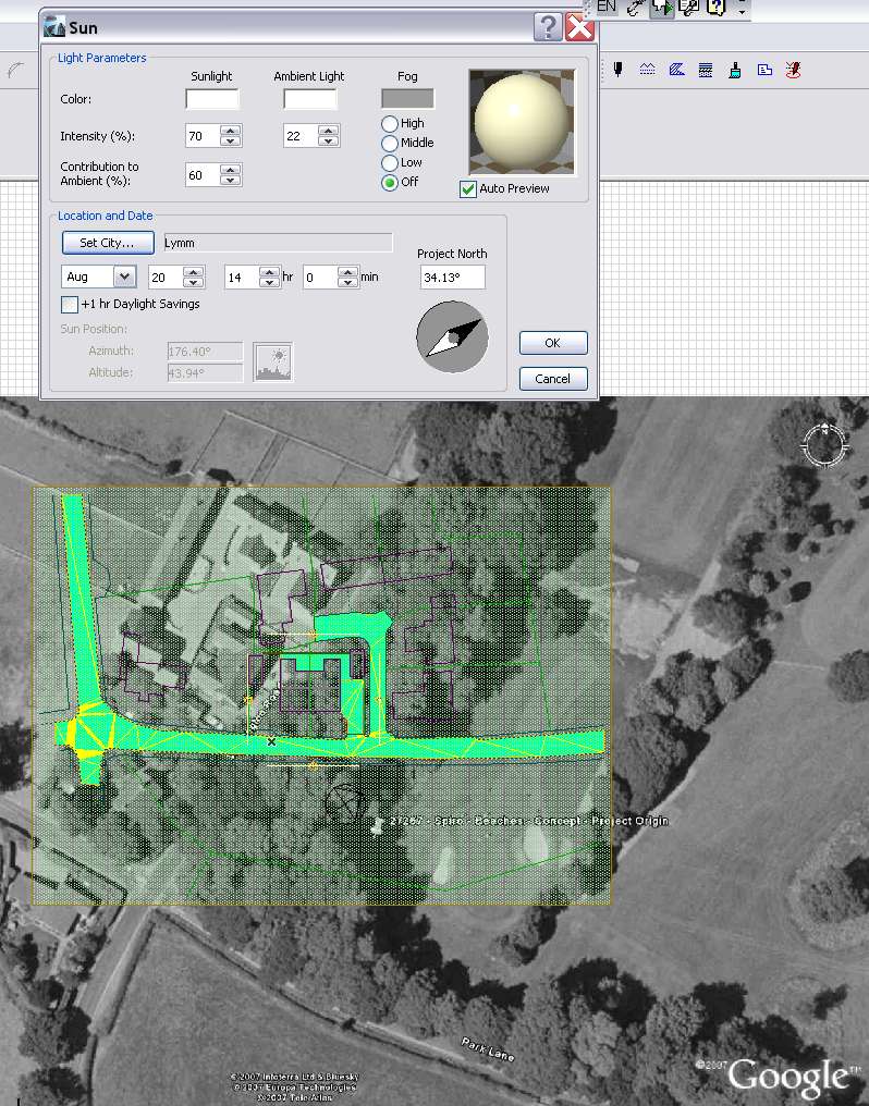
However, this doesn't seem to be the case. See screen dump.
Small development, set up in AC orthogonal to my Client's building.
This puts North at 34.13 degrees anti-clock above horizontal. (North Point is just visible below the horizontal road in the terrain model)
I have used Camera/Set City/Set North to locate the site and set the orientation.
On GE I have located the site, with it's North Point still set vertically - also in picture.
When the Snapshot is placed, it is imported as a horizontal rectangle matching the screen view. This leaves it's North at 90 degrees to horizontal.
There is no APPARENT self-correction or alignment mechanism.
(I have just dumped the picture roughly, no attempt at alignment)
Now... I COULD twist the GE Snapshot approx 56 degrees clockwise to get the two to align.
OR, I could twist the AC model 56 degrees anti-clock to same effect.
With the second option, the resulting 3D AC model and terrain would align with Google Earth but would be virtually unworkable in CAD.
BUT, with the first choice, although it would look good in AC and be workable, as the construction data is still orthogonal, the model would appear in GE twisted 56 degrees out of true.
In other words, the download does not infer the relationship of the two north points. (Which is what we are requesting)
NOW... this is where you say "but you should have set X to Y and it all clicks together!" Be good if you could.
Regarding the other point about a true real world setting out point. There doesn't appear to be sufficient precision in GE (only to integer degree accuracy) to hit say the corner of an existing building dead on. However, if the rotational alignment were addressed, this bit of dragging to get best fit would be quite acceptable.
I hope you are right in what you say about the self alignment of the GE screen shot and the AC site plan.
However, this doesn't seem to be the case. See screen dump.
Small development, set up in AC orthogonal to my Client's building.
This puts North at 34.13 degrees anti-clock above horizontal. (North Point is just visible below the horizontal road in the terrain model)
I have used Camera/Set City/Set North to locate the site and set the orientation.
On GE I have located the site, with it's North Point still set vertically - also in picture.
When the Snapshot is placed, it is imported as a horizontal rectangle matching the screen view. This leaves it's North at 90 degrees to horizontal.
There is no APPARENT self-correction or alignment mechanism.
(I have just dumped the picture roughly, no attempt at alignment)
Now... I COULD twist the GE Snapshot approx 56 degrees clockwise to get the two to align.
OR, I could twist the AC model 56 degrees anti-clock to same effect.
With the second option, the resulting 3D AC model and terrain would align with Google Earth but would be virtually unworkable in CAD.
BUT, with the first choice, although it would look good in AC and be workable, as the construction data is still orthogonal, the model would appear in GE twisted 56 degrees out of true.
In other words, the download does not infer the relationship of the two north points. (Which is what we are requesting)
NOW... this is where you say "but you should have set X to Y and it all clicks together!" Be good if you could.
Regarding the other point about a true real world setting out point. There doesn't appear to be sufficient precision in GE (only to integer degree accuracy) to hit say the corner of an existing building dead on. However, if the rotational alignment were addressed, this bit of dragging to get best fit would be quite acceptable.
Anonymous
Not applicable
Options
- Mark as New
- Bookmark
- Subscribe
- Mute
- Subscribe to RSS Feed
- Permalink
- Report Inappropriate Content
2007-08-24 04:49 PM
I've found two easy way to turn around the problem:
1- I've made another project, where I've positioned GE terrain and then, I've linked this project to the original project as a linked module rotated.
2- I've made another project, where I've positioned the original project as a linked module rotated (with the true north upside) and then I've positioned the GE terrain
The 1st is easier for me, but the second works when you export the model to GE
Anonymous
Not applicable
Options
- Mark as New
- Bookmark
- Subscribe
- Mute
- Subscribe to RSS Feed
- Permalink
- Report Inappropriate Content
2007-08-24 05:24 PM
Yeah, making a second version, whether by hotlink or as a cut down stand-alone shell appears to be the current best bet.
Still hoping that there is an inbuilt system in there some where!
Still hoping that there is an inbuilt system in there some where!
Learn and get certified!

Still looking?
