Turn on suggestions
Auto-suggest helps you quickly narrow down your search results by suggesting possible matches as you type.
Showing results for
Turn on suggestions
Auto-suggest helps you quickly narrow down your search results by suggesting possible matches as you type.
Showing results for
BIM Coordinator Program (INT) April 22, 2024
Find the next step in your career as a Graphisoft Certified BIM Coordinator!
Documentation
About Archicad's documenting tools, views, model filtering, layouts, publishing, etc.
- Graphisoft Community (INT)
- :
- Forum
- :
- Documentation
- :
- Most time efficient way to draw joinery detail dra...
Options
- Subscribe to RSS Feed
- Mark Topic as New
- Mark Topic as Read
- Pin this post for me
- Bookmark
- Subscribe to Topic
- Mute
- Printer Friendly Page
SOLVED!
Most time efficient way to draw joinery detail drawings?
Anonymous
Not applicable
Options
- Mark as New
- Bookmark
- Subscribe
- Mute
- Subscribe to RSS Feed
- Permalink
- Report Inappropriate Content
2020-03-17
02:01 AM
- last edited on
2023-05-30
12:22 PM
by
![]() Rubia Torres
Rubia Torres
I'm very new to archicad, I've only been using it for 2 weeks. My background is Autodesk - AutoCad and Revit.
I'm an interior designer so I have to do a lot of joinery drawings and etc and I just want to know the most time efficient way to create a joinery package.
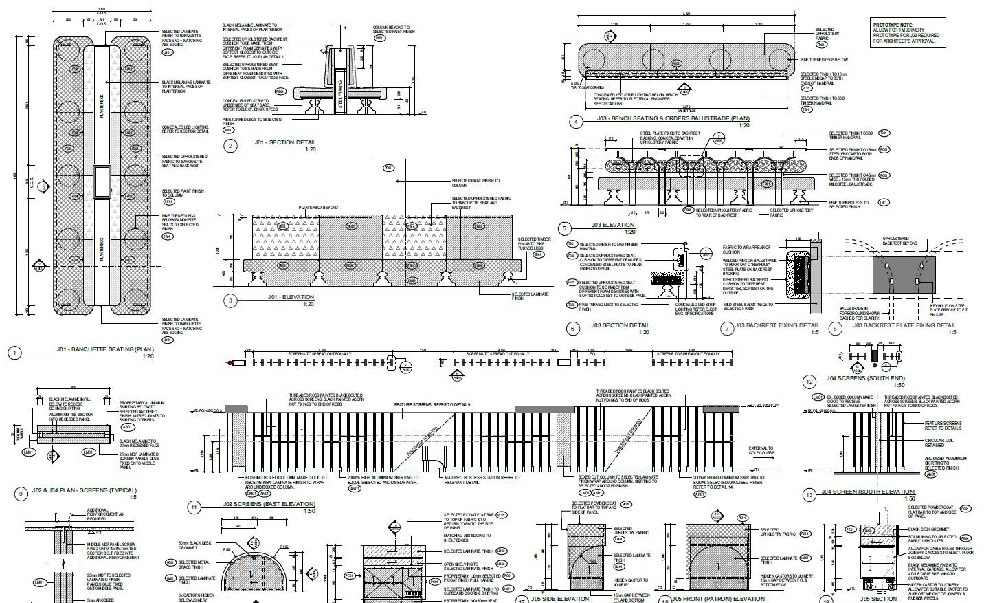
I've attached a screenshot of what a joinery package should look like at the firm I am in right now.
So basically, in a joinery package I would like to show a plan view, all relevant elevations and sections and also detail callouts etc (please have a look at the attached screenshot for clarification).
What I'm struggling with Archicad right now is the 2D line work it creates within a callout view source, I'm so used to Revit so when I first found out that Archicad callout view source turns everything within the view into 2D line I thought it was a bit weird but I do understand the benefits and advantage of having that option.. but right now I'm struggling to create elevation views from it.
I need to place elevation/section tags on the joinery floor plan and create elevation/sections views but because the joinery plan is a callout and it's 2D I can't elevate/section from that plan.. and I'm using cadimage cabinet so everything's there in 3D and ready to elevate for more detail drawings.
So this is what I'm currently doing now,
- first I create an elevation/section marker on the main floor plan and generate an elevation/section view
- and then I put that marker on to a new layer I created so I can hide it on the main floor plan
- and then I create another elevation/section marker on joinery callout plan and link them to the view I just created in the main floor plan.
it just seems like a lot of mucking around and not exactly straight forward process, just wondering if anyone has a better way of doing it?
Thanks heaps.
Solved! Go to Solution.
1 ACCEPTED SOLUTION
Accepted Solutions
Solution
Options
- Mark as New
- Bookmark
- Subscribe
- Mute
- Subscribe to RSS Feed
- Permalink
- Report Inappropriate Content
2020-03-17 03:06 AM
I don't use details or worksheets at all to produce large scaled plans - which is essentially what you are doing.
The method I use takes a little getting used to but it is all 'live' - no 2D details or worksheets that you have to 're-build' to update.
Essentially you create 2 views of you plan - one with no annotation layers and another with only annotation layers.
You combine these 2 views on you layouts to create a 'complete' view.
The advantage of this is you can crop the no annotation plan on the layout to hide the extents that you do not want to see.
The tricky bit is you can't crop while you are working on it in the plan view - so you have to ignore what will not actually be there.
Some people place a solid white fill with a hole in the middle to hide the extents, but this is just as awkward as you are for ever adjusting display order of elements.
The elevations and sections you do as you are now - hiding the markers in a layer that does not show on plan but does show with the annotation layers.
Actually I just have objects I place in the annotation layer to show the elevation markers - but they could be the real elevation markers.
Here is a link to a post that explains the process - I hope it helps.
https://archicad-talk.graphisoft.com/viewtopic.php?p=182148
Barry.
The method I use takes a little getting used to but it is all 'live' - no 2D details or worksheets that you have to 're-build' to update.
Essentially you create 2 views of you plan - one with no annotation layers and another with only annotation layers.
You combine these 2 views on you layouts to create a 'complete' view.
The advantage of this is you can crop the no annotation plan on the layout to hide the extents that you do not want to see.
The tricky bit is you can't crop while you are working on it in the plan view - so you have to ignore what will not actually be there.
Some people place a solid white fill with a hole in the middle to hide the extents, but this is just as awkward as you are for ever adjusting display order of elements.
The elevations and sections you do as you are now - hiding the markers in a layer that does not show on plan but does show with the annotation layers.
Actually I just have objects I place in the annotation layer to show the elevation markers - but they could be the real elevation markers.
Here is a link to a post that explains the process - I hope it helps.
Barry.
One of the forum moderators.
Versions 6.5 to 27
Dell XPS- i7-6700 @ 3.4Ghz, 16GB ram, GeForce GTX 960 (2GB), Windows 10
Lenovo Thinkpad - i7-1270P 2.20 GHz, 32GB RAM, Nvidia T550, Windows 11
Versions 6.5 to 27
Dell XPS- i7-6700 @ 3.4Ghz, 16GB ram, GeForce GTX 960 (2GB), Windows 10
Lenovo Thinkpad - i7-1270P 2.20 GHz, 32GB RAM, Nvidia T550, Windows 11
3 REPLIES 3
Solution
Options
- Mark as New
- Bookmark
- Subscribe
- Mute
- Subscribe to RSS Feed
- Permalink
- Report Inappropriate Content
2020-03-17 03:06 AM
I don't use details or worksheets at all to produce large scaled plans - which is essentially what you are doing.
The method I use takes a little getting used to but it is all 'live' - no 2D details or worksheets that you have to 're-build' to update.
Essentially you create 2 views of you plan - one with no annotation layers and another with only annotation layers.
You combine these 2 views on you layouts to create a 'complete' view.
The advantage of this is you can crop the no annotation plan on the layout to hide the extents that you do not want to see.
The tricky bit is you can't crop while you are working on it in the plan view - so you have to ignore what will not actually be there.
Some people place a solid white fill with a hole in the middle to hide the extents, but this is just as awkward as you are for ever adjusting display order of elements.
The elevations and sections you do as you are now - hiding the markers in a layer that does not show on plan but does show with the annotation layers.
Actually I just have objects I place in the annotation layer to show the elevation markers - but they could be the real elevation markers.
Here is a link to a post that explains the process - I hope it helps.
https://archicad-talk.graphisoft.com/viewtopic.php?p=182148
Barry.
The method I use takes a little getting used to but it is all 'live' - no 2D details or worksheets that you have to 're-build' to update.
Essentially you create 2 views of you plan - one with no annotation layers and another with only annotation layers.
You combine these 2 views on you layouts to create a 'complete' view.
The advantage of this is you can crop the no annotation plan on the layout to hide the extents that you do not want to see.
The tricky bit is you can't crop while you are working on it in the plan view - so you have to ignore what will not actually be there.
Some people place a solid white fill with a hole in the middle to hide the extents, but this is just as awkward as you are for ever adjusting display order of elements.
The elevations and sections you do as you are now - hiding the markers in a layer that does not show on plan but does show with the annotation layers.
Actually I just have objects I place in the annotation layer to show the elevation markers - but they could be the real elevation markers.
Here is a link to a post that explains the process - I hope it helps.
Barry.
One of the forum moderators.
Versions 6.5 to 27
Dell XPS- i7-6700 @ 3.4Ghz, 16GB ram, GeForce GTX 960 (2GB), Windows 10
Lenovo Thinkpad - i7-1270P 2.20 GHz, 32GB RAM, Nvidia T550, Windows 11
Versions 6.5 to 27
Dell XPS- i7-6700 @ 3.4Ghz, 16GB ram, GeForce GTX 960 (2GB), Windows 10
Lenovo Thinkpad - i7-1270P 2.20 GHz, 32GB RAM, Nvidia T550, Windows 11
Anonymous
Not applicable
Options
- Mark as New
- Bookmark
- Subscribe
- Mute
- Subscribe to RSS Feed
- Permalink
- Report Inappropriate Content
2020-03-17 05:04 AM
Barry wrote:Thank you Barry! I will experiment if your method works best for the documentation style I'm after. it's such a shame that it's not a straight forward process to produce live drawings.
I don't use details or worksheets at all to produce large scaled plans - which is essentially what you are doing.
The method I use takes a little getting used to but it is all 'live' - no 2D details or worksheets that you have to 're-build' to update.
Essentially you create 2 views of you plan - one with no annotation layers and another with only annotation layers.
You combine these 2 views on you layouts to create a 'complete' view.
The advantage of this is you can crop the no annotation plan on the layout to hide the extents that you do not want to see.
The tricky bit is you can't crop while you are working on it in the plan view - so you have to ignore what will not actually be there.
Some people place a solid white fill with a hole in the middle to hide the extents, but this is just as awkward as you are for ever adjusting display order of elements.
The elevations and sections you do as you are now - hiding the markers in a layer that does not show on plan but does show with the annotation layers.
Actually I just have objects I place in the annotation layer to show the elevation markers - but they could be the real elevation markers.
Here is a link to a post that explains the process - I hope it helps.
https://archicad-talk.graphisoft.com/viewtopic.php?p=182148
Barry.
I felt a bit of a let down when the worksheets are turned into 2D fills and lines and even though there's a "re-build" option available.. I can't image doing that to a large joinery documentation package. I'm only doing a test project right now to learn Archicad and I haven't even used it for a real project yet and it sounds like a chaos already.
Anonymous
Not applicable
Options
- Mark as New
- Bookmark
- Subscribe
- Mute
- Subscribe to RSS Feed
- Permalink
- Report Inappropriate Content
2021-06-09 07:30 PM
Hi Sabrinamo
How did you end up going with your joinery workflow. I am new from Revit to Archicad and having the same issue as you.
I am keen to know how you went.
Thanks
How did you end up going with your joinery workflow. I am new from Revit to Archicad and having the same issue as you.
I am keen to know how you went.
Thanks
Learn and get certified!

Related articles
- Editable master layout items in Wishes
- [ LONG POST ] - I'm a new user, hoping to ask if ArchiCAD is the best program for my use-case. in General discussions
- Off shore outsourcing documentation Mixed Archicad versions in Project data & BIM
- Printing from Project Map ignores lineweights in Documentation
- New BIMcloud server - moving old projects in Teamwork & BIMcloud
Still looking?
