Turn on suggestions
Auto-suggest helps you quickly narrow down your search results by suggesting possible matches as you type.
Showing results for
Turn on suggestions
Auto-suggest helps you quickly narrow down your search results by suggesting possible matches as you type.
Showing results for
BIM Coordinator Program (INT) April 22, 2024
Find the next step in your career as a Graphisoft Certified BIM Coordinator!
Wishes
Post your wishes about Graphisoft products: Archicad, BIMx, BIMcloud, and DDScad.
- Graphisoft Community (INT)
- :
- Forum
- :
- Wishes
- :
- Re: Need a reference level for arbitrary TBM as we...
Options
- Subscribe to RSS Feed
- Mark Topic as New
- Mark Topic as Read
- Pin this post for me
- Bookmark
- Subscribe to Topic
- Mute
- Printer Friendly Page
Need a reference level for arbitrary TBM as well as Altitude
Anonymous
Not applicable
Options
- Mark as New
- Bookmark
- Subscribe
- Mute
- Subscribe to RSS Feed
- Permalink
- Report Inappropriate Content
2013-04-24 04:24 AM
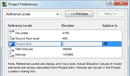
Please see the attached 'photoshopped' screen-capture to show what I'd like to see. In this example, the surveyor used an arbitrary TBM set at 50.00, but the actual altitude is over 100m
Altitude has increasing relevance to other aspects of the design process than mere height above sea level (eg. shadow calculations, optimising solar panel orientation). So, when a surveyor uses a TBM, it's useful to have that as a reference level IN ADDITION TO the actual altitude of the site, rather than changing the altitude to suit an arbitrary TBM and thereby screwing things up elsewhere.
Labels:
- Labels:
-
User Interface wishes
4 REPLIES 4
Options
- Mark as New
- Bookmark
- Subscribe
- Mute
- Subscribe to RSS Feed
- Permalink
- Report Inappropriate Content
2013-04-24 12:41 PM
Can't you just use a reference offset?
Intel i7-6700@3.4GHz 16g
GeForce GTX 745 4g HP Pavilion 25xw
Windows 10 Archicad 26 USA Full
GeForce GTX 745 4g HP Pavilion 25xw
Windows 10 Archicad 26 USA Full
Anonymous
Not applicable
Options
- Mark as New
- Bookmark
- Subscribe
- Mute
- Subscribe to RSS Feed
- Permalink
- Report Inappropriate Content
2013-04-24 01:02 PM
I don't know. When you get a moment, can you please elaborate?
Anonymous
Not applicable
Options
- Mark as New
- Bookmark
- Subscribe
- Mute
- Subscribe to RSS Feed
- Permalink
- Report Inappropriate Content
2013-04-25 05:13 PM
I just voted "essential" not so much for this limited request but more for an expanded reference level function. I would like to see an unlimited number of levels and the ability to make them global or link them to stories. This would allow AC to not only catch up to but surpass Revit's levels functions.
Anonymous
Not applicable
Options
- Mark as New
- Bookmark
- Subscribe
- Mute
- Subscribe to RSS Feed
- Permalink
- Report Inappropriate Content
2013-04-26 01:08 AM
I agree Matthew,
I'd just got the impression from my research before posting that people had failed with that particular request... so I thought I'd try a slightly more, um, incremental request to see how that went😉
I'd just got the impression from my research before posting that people had failed with that particular request... so I thought I'd try a slightly more, um, incremental request to see how that went
Learn and get certified!

Related articles
- Reference levels and how to be able to see objects on their level and above + above in Modeling
- Ability to save Elevation/Level Dimension to show Sea or Reference levels values as a Favorite in Wishes
- GDL objects - Materials vs surfaces in Libraries & objects
- Changing the reference level 0.00 in Documentation
- Include Location Settings in Project Information or for Autotext Reference in Wishes
Still looking?
