Turn on suggestions
Auto-suggest helps you quickly narrow down your search results by suggesting possible matches as you type.
Showing results for
Turn on suggestions
Auto-suggest helps you quickly narrow down your search results by suggesting possible matches as you type.
Showing results for
- Graphisoft Community (INT)
- :
- Forum
- :
- Documentation
- :
- Referencing sections/ elevations to SEA LEVEL
Options
- Subscribe to RSS Feed
- Mark Topic as New
- Mark Topic as Read
- Pin this post for me
- Bookmark
- Subscribe to Topic
- Mute
- Printer Friendly Page
Documentation
About Archicad's documenting tools, views, model filtering, layouts, publishing, etc.
Referencing sections/ elevations to SEA LEVEL
Anonymous
Not applicable
Options
- Mark as New
- Bookmark
- Subscribe
- Mute
- Subscribe to RSS Feed
- Permalink
- Report Inappropriate Content
2010-12-28
06:36 PM
- last edited on
2023-05-30
10:06 AM
by
![]() Rubia Torres
Rubia Torres
2010-12-28
06:36 PM
I am trying to have my elevation markers in sections and elevations to reference the Sea Level, not my project zero. I know how to change the markers' properties to do this, but the sea level of my project is wrong. Instead of reading 195.50' at the ground floor, it reads 23' (for example).
How do I change the sea level of my project? I suppose i could move my entire project vertically to the correct location, but i am trying to avoid that. We have Hotlinks connected, and our story settings are fairly complicated. Im sure moving the building up is not the way to go anyway. Maybe there is a simple answer to this, where i can just set the sea level.
Any help would be great. Suggestions on how to solve this problem would be appreciated too.
Thanks in Advance
Labels:
- Labels:
-
Elevations
6 REPLIES 6
Anonymous
Not applicable
Options
- Mark as New
- Bookmark
- Subscribe
- Mute
- Subscribe to RSS Feed
- Permalink
- Report Inappropriate Content
2010-12-28 08:33 PM
2010-12-28
08:33 PM
As I recall it's in Options>Project Preferences>Reference Levels & Project North.
Options
- Mark as New
- Bookmark
- Subscribe
- Mute
- Subscribe to RSS Feed
- Permalink
- Report Inappropriate Content
2011-04-03 11:14 PM
2011-04-03
11:14 PM
I just wanted to get a feel for others' experience out there...
While editing a TERRAIN MESH in 3d and with the COORDINATES BOX set to show SEA LEVEL... I cannot adjust the height of a point by simply typing in it's elevation above sea level... The number get's interpreted as an elevation above MESH BASE...
This seems extremely counter intuitive and useless...
I may be missing something, but I've tried a number of ways and the only real way to make adjustments is knowing it's relative height to the mesh base.
Even typing in 1'+ while in SEA LEVEL mode pushes the point to the sea level elevation above MESH BASE...
Let me know if I've explained this coherently...
Looking forward to your comments.
Duane
Visual Frontiers
AC25 :|: AC26 :|: AC27
:|: Enscape3.4:|:TwinMotion
DellXPS 4.7ghz i7:|: 8gb GPU 1070ti / Alienware M18 Laptop
Visual Frontiers
AC25 :|: AC26 :|: AC27
:|: Enscape3.4:|:TwinMotion
DellXPS 4.7ghz i7:|: 8gb GPU 1070ti / Alienware M18 Laptop
Options
- Mark as New
- Bookmark
- Subscribe
- Mute
- Subscribe to RSS Feed
- Permalink
- Report Inappropriate Content
2011-04-04 06:01 AM
2011-04-04
06:01 AM
Duane:
Seems to work correctly for me in 3D (and 2D). I select the point, choose "elevate mesh point" from the pet palette and type the sea level elevation in "Z".
...and BTW.. you were RICKROLLED my friend.
Seems to work correctly for me in 3D (and 2D). I select the point, choose "elevate mesh point" from the pet palette and type the sea level elevation in "Z".
...and BTW.. you were RICKROLLED my friend.
Marc Corney, Architect
Red Canoe Architecture, P. A.
Mac OS 10.15.7 (Catalina) //// Mac OS 14.5 (Sonoma)
Processor: 3.6 GHz 8-Core Intel Core i9 //// Apple M2 Max
Memory: 48 GB 2667 MHz DDR4 //// 32 GB
Graphics: Radeon Pro 580X 8GB //// 12C CPU, 30C GPU
ArchiCAD 25 (5010 USA Full) //// ArchiCAD 27 (4030 USA Full)
Red Canoe Architecture, P. A.
Mac OS 10.15.7 (Catalina) //// Mac OS 14.5 (Sonoma)
Processor: 3.6 GHz 8-Core Intel Core i9 //// Apple M2 Max
Memory: 48 GB 2667 MHz DDR4 //// 32 GB
Graphics: Radeon Pro 580X 8GB //// 12C CPU, 30C GPU
ArchiCAD 25 (5010 USA Full) //// ArchiCAD 27 (4030 USA Full)
Options
- Mark as New
- Bookmark
- Subscribe
- Mute
- Subscribe to RSS Feed
- Permalink
- Report Inappropriate Content
2011-04-04 01:53 PM
2011-04-04
01:53 PM
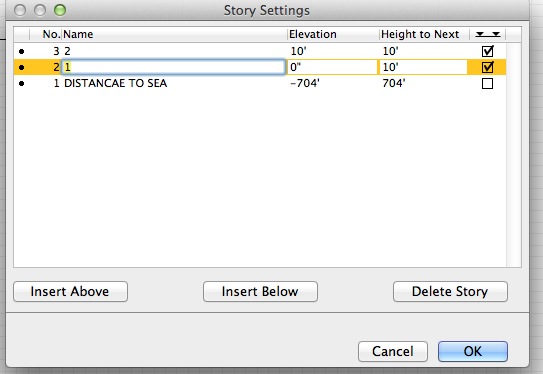
I've found the best solution to the shortcomings of reference levels is to make project zero the same as sea level.
Just add a 'buffer' 0. Story (1. Story in the US?) called something like 'Distance to Sea Level'. Then give that story a height that matches the distance to sea level and uncheck the story level lines. Now you don't have to reference elements, including elevation and level dimensions, to anything but project zero. And if that distance ever changes you only ever need to adjust it in one place and everything updates.
The only time it becomes an issue is when IFCs are imported, but they're easy enough to elevate.
Sounds dodgey, but it works a treat. Give it a test and see what you think!
Cheers,
Link.
Options
- Mark as New
- Bookmark
- Subscribe
- Mute
- Subscribe to RSS Feed
- Permalink
- Report Inappropriate Content
2013-11-22 08:26 PM
Options
- Mark as New
- Bookmark
- Subscribe
- Mute
- Subscribe to RSS Feed
- Permalink
- Report Inappropriate Content
2013-11-22 08:47 PM
2013-11-22
08:47 PM
For your DISTANCE TO SEA storey, try making the elevation 0 and the height to next 704.
Cheers,
Link.
Cheers,
Link.

Related articles
- Is it possible to locate placed instances of embedded library objects? in Libraries & objects
- AC 28 Skylight Roof cut fill default can't be changed in Libraries & objects
- Excessive redraw times for sections/elevations in Documentation
- Product Roadmap - Shadow Elevations in General discussions
- Only reference lines move while moving any object in 3D, Elevation and Section! in Modeling
Still looking?
