Turn on suggestions
Auto-suggest helps you quickly narrow down your search results by suggesting possible matches as you type.
Showing results for
Turn on suggestions
Auto-suggest helps you quickly narrow down your search results by suggesting possible matches as you type.
Showing results for
- Graphisoft Community (INT)
- :
- Forum
- :
- Collaboration with other software
- :
- Terrain 5 import problem
Options
- Subscribe to RSS Feed
- Mark Topic as New
- Mark Topic as Read
- Pin this post for me
- Bookmark
- Subscribe to Topic
- Mute
- Printer Friendly Page
Collaboration with other software
About model and data exchange with 3rd party solutions: Revit, Solibri, dRofus, Bluebeam, structural analysis solutions, and IFC, BCF and DXF/DWG-based exchange, etc.
Terrain 5 import problem
Anonymous
Not applicable
Options
- Mark as New
- Bookmark
- Subscribe
- Mute
- Subscribe to RSS Feed
- Permalink
- Report Inappropriate Content
2019-05-26 05:40 PM
2019-05-26
05:40 PM
I saw one post where it suggested using the mesh tool, but the mesh tool is greyed out and not usable.
Labels:
- Labels:
-
Data Exchange
3 REPLIES 3
Options
- Mark as New
- Bookmark
- Subscribe
- Mute
- Subscribe to RSS Feed
- Permalink
- Report Inappropriate Content
2019-05-27 09:02 AM
2019-05-27
09:02 AM
Cause dwg deals with a 2D import so the 3D informations (in your dwg) are not processed
You should try to import a xyz or a e57 file to import your ground
By this way :
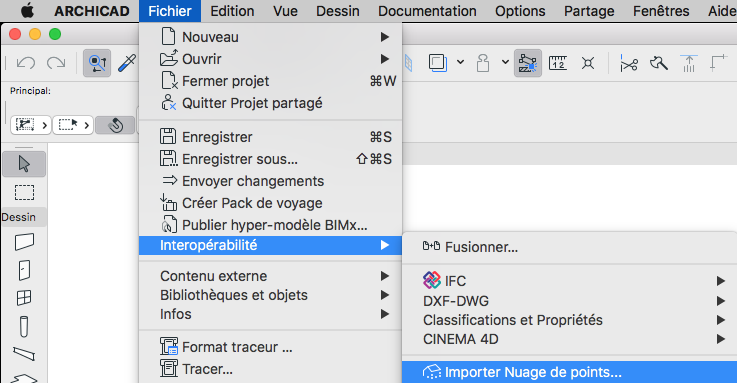
You should try to import a xyz or a e57 file to import your ground
By this way :
Anonymous
Not applicable
Options
- Mark as New
- Bookmark
- Subscribe
- Mute
- Subscribe to RSS Feed
- Permalink
- Report Inappropriate Content
2019-05-27 09:19 PM
2019-05-27
09:19 PM
Thanks Christophe
In the UK Ordnance Survey map export, I have 3 download options.
ASC11 Grid (ASC)
3D TIN (DWG)..........the one I downloaded
3D PDF (PDF)
That's all. I could have downloaded a simple contour map, but I liked the idea of working with a series of spot levels.
In the UK Ordnance Survey map export, I have 3 download options.
ASC11 Grid (ASC)
3D TIN (DWG)..........the one I downloaded
3D PDF (PDF)
That's all. I could have downloaded a simple contour map, but I liked the idea of working with a series of spot levels.
Options
- Mark as New
- Bookmark
- Subscribe
- Mute
- Subscribe to RSS Feed
- Permalink
- Report Inappropriate Content
2019-05-27 09:48 PM
2019-05-27
09:48 PM
There are some solutions here :
https://helpcenter.graphisoft.com/knowledgebase/25573/
https://helpcenter.graphisoft.com/knowledgebase/25573/
Suggested content
- LAND4 add-on // Current issues and possible ideas for alternatives in Modeling
- DWG import/export in Collaboration with other software
- Workflow between Modules and Bimcloud Saas in Teamwork & BIMcloud
- Problem with Bimmtool for point cloud display resolution. in Collaboration with other software
- Import and export IFC file from Civil in Collaboration with other software
Still looking?
