Turn on suggestions
Auto-suggest helps you quickly narrow down your search results by suggesting possible matches as you type.
Showing results for
Turn on suggestions
Auto-suggest helps you quickly narrow down your search results by suggesting possible matches as you type.
Showing results for
- Graphisoft Community (INT)
- :
- Forum
- :
- Collaboration with other software
- :
- Coordinate systems / height elevation
Options
- Subscribe to RSS Feed
- Mark Topic as New
- Mark Topic as Read
- Pin this post for me
- Bookmark
- Subscribe to Topic
- Mute
- Printer Friendly Page
Collaboration with other software
About model and data exchange with 3rd party solutions: Revit, Solibri, dRofus, Bluebeam, structural analysis solutions, and IFC, BCF and DXF/DWG-based exchange, etc.
Coordinate systems / height elevation
Options
- Mark as New
- Bookmark
- Subscribe
- Mute
- Subscribe to RSS Feed
- Permalink
- Report Inappropriate Content
2019-07-12 07:47 AM
2019-07-12
07:47 AM
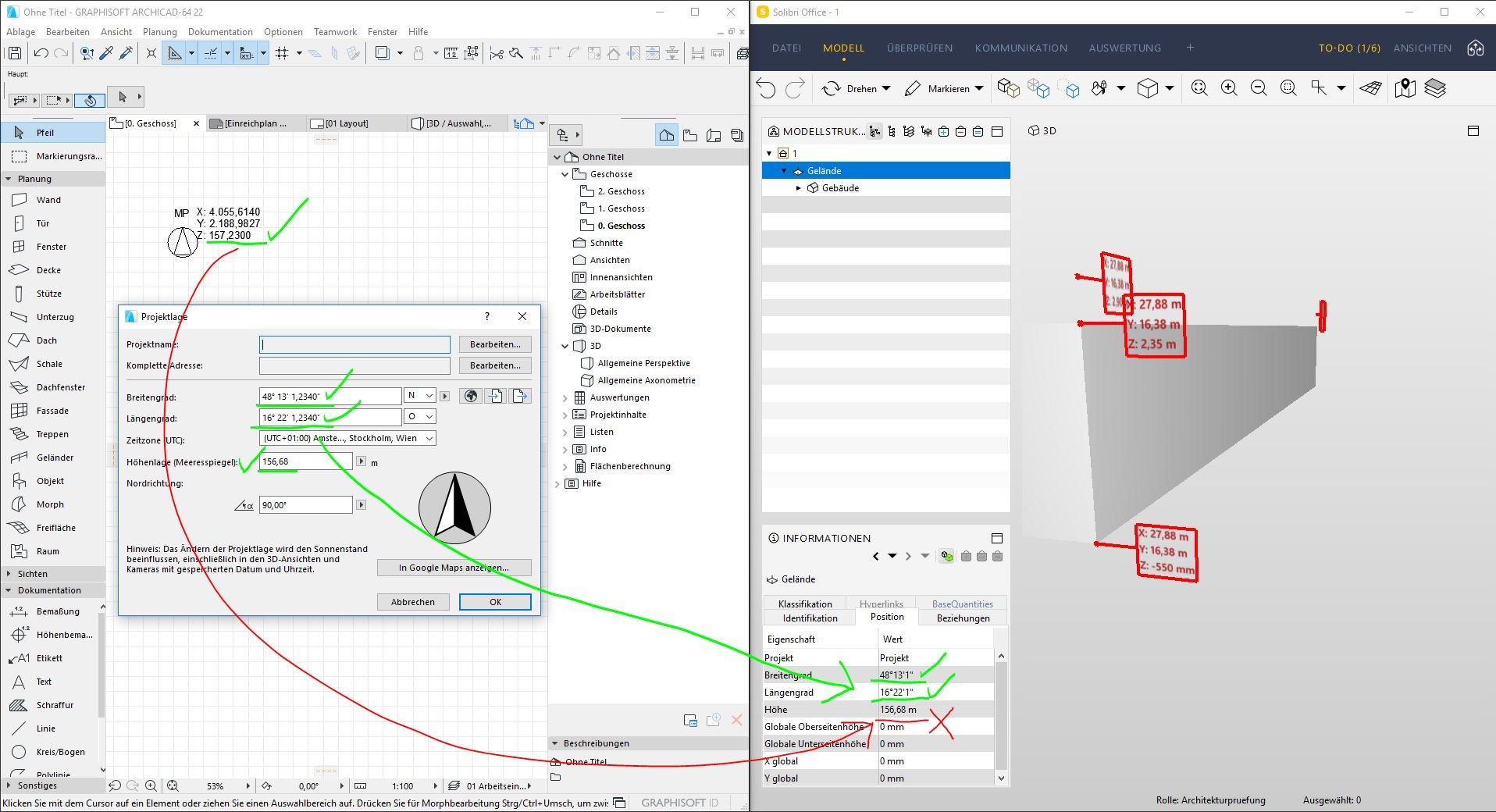
But there is a slight problem with the national elevation, that is connected to a national surveying datum. We have a file with defined coordinates: lat, lon and elevation as a reference for our project. This elevation is defined at 157,23m. I have defined the height 156,68m which is my ±0,00 ground floor. This means, the survey point has in its settings 55cm, to bring it higher than the project origin (156,68). Since I am exporting an IFC based on the survey point (not project origin) shouldn’t the height elevation in the IFC be 157,23m respectively the height of the survery point? In this case archicad exports the height elevation of my project origin.
One thing that comes to my mind solving this issue is definig the 157,23 in the project location, and to define the ±0,00 as another Reference height in archicad.
What I am doing wrong here?
The BIMster @ AllesWirdGut
Currently: Archicad 26
User since Archicad 6.5 (2001)
Currently: Archicad 26
User since Archicad 6.5 (2001)
Labels:
- Labels:
-
Data Exchange
1 REPLY 1
Options
- Mark as New
- Bookmark
- Subscribe
- Mute
- Subscribe to RSS Feed
- Permalink
- Report Inappropriate Content
2019-07-23 03:29 PM
2019-07-23
03:29 PM
I don't have the GER library loaded now, but I presume the Survey Point element should have the same functionality. Did you check the correct level settings there? I have defined your levels in the Project Location menu (in der Projektlage) for better understanding.
Maybe you have wrong data in the reference level setting. I have set your project zero level to 156,68 above sea level and the 1st reference level to +0,55. I can't get the same numbers as you did on my Survey Point Marker.
Do you have your reference level set to the absolute value of -157,23? This way only I get the same number on my Survey Point Marker...
| Archicad 4.5 - 29
| HP Z840 | 2× E5-2643 v4 | 64 GB RAM | Quadro M5000 | Windows 10 Pro x64
| HP Z4 G4 | W-2245 | 64 GB RAM | RTX A4000 | Windows 11
Suggested content
- Need to extract X, Y, Z of Point Clouds in schedules - But how? in Project data & BIM
- Is a Survey Point necessary? in Collaboration with other software
- [ LONG POST ] - I'm a new user, hoping to ask if ArchiCAD is the best program for my use-case. in General discussions
- Survey coordinates in section or elevation view in Documentation
- Importing the point cloud on the same coordinate system in Collaboration with other software
Still looking?
