Turn on suggestions
Auto-suggest helps you quickly narrow down your search results by suggesting possible matches as you type.
Showing results for
Turn on suggestions
Auto-suggest helps you quickly narrow down your search results by suggesting possible matches as you type.
Showing results for
- Graphisoft Community (INT)
- :
- Forum
- :
- Collaboration with other software
- :
- Re: New Survey Point erratic coordinates behaviour
Options
- Subscribe to RSS Feed
- Mark Topic as New
- Mark Topic as Read
- Pin this post for me
- Bookmark
- Subscribe to Topic
- Mute
- Printer Friendly Page
Collaboration with other software
About model and data exchange with 3rd party solutions: Revit, Solibri, dRofus, Bluebeam, structural analysis solutions, and IFC, BCF and DXF/DWG-based exchange, etc.
New Survey Point erratic coordinates behaviour
Options
- Mark as New
- Bookmark
- Subscribe
- Mute
- Subscribe to RSS Feed
- Permalink
- Report Inappropriate Content
2021-08-03 06:36 PM
2021-08-03
06:36 PM
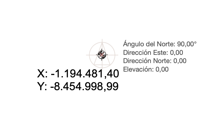
I'm struggling with the new survey point, which I thought would solve my long history of problems with topographic coordinates objects.
I've found that the new Survey Point Object it doesn't work at all with alreaay started AC24 projects, I have to create a new project with fresh AC25 parameters for it to work, but as soon as I add some DXF file with topographic or urban planning data to work with, it starts to act weird, and shows X and Y data that are always wrong.
The survey point object, positioned just in the middle of the Survey Point at X:0,00 Y:0,00 coordinates, shows erratic positions, sometimes thousands km appart, as in the attached image.
What am I doing wrong?
Thanks
Labels:
- Labels:
-
Data Exchange
3 REPLIES 3
Options
- Mark as New
- Bookmark
- Subscribe
- Mute
- Subscribe to RSS Feed
- Permalink
- Report Inappropriate Content
2021-08-10 01:48 PM
2021-08-10
01:48 PM
Hello,
Thank you very much for the question!
Based on the screenshot, it seems like you placed the
As I can see, the coordinates of the Survey Coordinate Object are very large, suggesting a Far from Origin issue. Generally, this happens when there is an element (a line or a piece of text) placed very far from the origin. The new Native Survey point still reports a correct location in this situation (0,0), but the
The new Native Survey Point is meant to be used as a common reference point to facilitate coordination of models. For example, if you move the Native Survey Point to the real-world location, the origin would report the correct X and Y number instead of 0. For further information, please refer to this guide.
I hope this answers your questions! Please let me know if you have any further issues!
Best regards,
Minh
Minh Nguyen
Technical Support Engineer
GRAPHISOFT
Options
- Mark as New
- Bookmark
- Subscribe
- Mute
- Subscribe to RSS Feed
- Permalink
- Report Inappropriate Content
2021-08-30 11:59 AM
2021-08-30
11:59 AM
I have gotten this to work by moving the Survey Point location by putting a negative value in the "Easting" and "Northing" fields, so that the survey point is placed at the world 0 (for the system we use) in relation to the archicad files local origin. Then by using the new Survey Coordinate Object 25 (which for some reason is translated into Swedish in my version, but not correctly) and setting it to use the Survey Point for coordinate rather than project origin, I am able to get a schedule listing the coordinates correctly (I had to change the schedule field to use the new parameters under General>Survey Coordinate X, Y and Z.
This is a great improvement and so far seems to work very well, however I have one question/request: is it possible to use the survey point as a reference when drawing and placing objects? In the "Tracker and Coordinate input"-settings we can set it to "Show X-Y-Coordinates relative to the user origin in Tracker" which makes it possible to place and draw things on precise x-y-coordinates, relative to the files origin. But can this be switched to be relative to the survey point?
This is a great improvement and so far seems to work very well, however I have one question/request: is it possible to use the survey point as a reference when drawing and placing objects? In the "Tracker and Coordinate input"-settings we can set it to "Show X-Y-Coordinates relative to the user origin in Tracker" which makes it possible to place and draw things on precise x-y-coordinates, relative to the files origin. But can this be switched to be relative to the survey point?
| AC 28 Int | Win10 | i7-7800X | 32 GB | GeForce RTX 2060 6GB |
Options
- Mark as New
- Bookmark
- Subscribe
- Mute
- Subscribe to RSS Feed
- Permalink
- Report Inappropriate Content
2021-09-02 02:15 PM
2021-09-02
02:15 PM
Hello,
Thank you very much for the idea!
As a workaround, what if we temporarily set the user origin to the center of the Survey Point, then using the tracker input (and with the option above active), we can place objects based on the Survey Point coordinates. When we finish, it's easy to reset the user custom origin. Would that work for you?
Best regards,
Minh
Minh Nguyen
Technical Support Engineer
GRAPHISOFT
Suggested content
- Cannot Reply to Thread in General discussions
- Archicad 26 APPLE SILICON VERSION BUGS? in Documentation
- "Coordinate Dimension 25.gsm" showing wrong Project Origin coordinates in Documentation
- New Survey Point erratic coordinates behaviour in Collaboration with other software
- Un-grouping deselection bug? in Modeling
Still looking?
