
Turn on suggestions
Auto-suggest helps you quickly narrow down your search results by suggesting possible matches as you type.
Showing results for
EN
Turn on suggestions
Auto-suggest helps you quickly narrow down your search results by suggesting possible matches as you type.
Showing results for
- English
- :
- Forum
- :
- Collaboration with other software
- :
- Importing Environment Agency Lidar
Options
- Subscribe to RSS Feed
- Mark Topic as New
- Mark Topic as Read
- Pin this post for me
- Bookmark
- Subscribe to Topic
- Mute
- Printer Friendly Page
AustinACD
Participant
Options
- Mark as New
- Bookmark
- Subscribe
- Mute
- Subscribe to RSS Feed
- Permalink
- Report Inappropriate Content
2018-11-01 02:31 PM
Importing Environment Agency Lidar
2018-11-01
02:31 PM
I've a query that I've not managed to dig out an answer too... In the UK the environment agency has released open source data, this includes LIDAR scans. https://environment.data.gov.uk/ds/survey/#/survey
I'm trying to work out how to create either a mesh/morph/3D element of a site from this data. I've never experimented/experienced this data or GIS software, has anyone had any luck converting/importing this data?
Are you able to talk me through how to do this?
Thanks in advance
Austin
Read-Only
Labels:
- Labels:
-
Data Exchange
2 Replies 2
Anonymous
Not applicable
Options
- Mark as New
- Bookmark
- Subscribe
- Mute
- Subscribe to RSS Feed
- Permalink
- Report Inappropriate Content
2018-11-07 05:14 AM
2018-11-07
05:14 AM
Try to use a GIS, generate contours, export to dwg and import to Archicad. Combine contours with mesh to generate terrain.
tsturm
Newcomer
Options
- Mark as New
- Bookmark
- Subscribe
- Mute
- Subscribe to RSS Feed
- Permalink
- Report Inappropriate Content
2020-11-18 09:55 PM
2020-11-18
09:55 PM
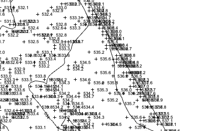
i asked my Civil engineer if the data set he was using for the contours we in 3D and if he could send me the mesh or surface. What i received from them is something called a LiDAR. The included image is what I see when I import the file into AC 24. There is nothing that AC sees as 3D data. I would need to make something 3D from this data is my presumption. Has anyone taken the LiDAR and made it into something 3D before it comes into AC? Or is the best work flow to bring in flat CAD contours and build up a mesh from this data?

Terrence Sturm, Architect
_______________
MBP OSX 10.15.4 Quad Core Intel i7 2.2hz
AC 17 build 5019
AC 22 build 7000
AC 23 build
AC 24 build 5000
_______________
MBP OSX 10.15.4 Quad Core Intel i7 2.2hz
AC 17 build 5019
AC 22 build 7000
AC 23 build
AC 24 build 5000
Still looking?
Suggested topics
- Can not import work environment in AC28 in Installation & update
- IFC Import - Messy homestories in Collaboration with other software
- Importing Work Environment Not Working in Installation & update
- Exporting to Excel changes certain values in Project data & BIM
- Shift key doesn't constrain cursor in Installation & update
