
Turn on suggestions
Auto-suggest helps you quickly narrow down your search results by suggesting possible matches as you type.
Showing results for
EN
Turn on suggestions
Auto-suggest helps you quickly narrow down your search results by suggesting possible matches as you type.
Showing results for
- English
- :
- Forum
- :
- Collaboration with other software
- :
- ArchiTerra
Options
- Subscribe to RSS Feed
- Mark Topic as New
- Mark Topic as Read
- Pin this post for me
- Bookmark
- Subscribe to Topic
- Mute
- Printer Friendly Page
Anonymous
Not applicable
Options
- Mark as New
- Bookmark
- Subscribe
- Mute
- Subscribe to RSS Feed
- Permalink
- Report Inappropriate Content
2007-06-29 05:46 PM
ArchiTerra
2007-06-29
05:46 PM

32 Replies 32
Anonymous
Not applicable
Options
- Mark as New
- Bookmark
- Subscribe
- Mute
- Subscribe to RSS Feed
- Permalink
- Report Inappropriate Content
2007-07-02 07:53 PM
2007-07-02
07:53 PM
Yeah the Factory S.E. is set to 2-meters. (I envy the metric world). but it will only come into play on slopped or "wavy" sites.
From the AT Users Guide on page 58, if using a polyline to create the pavement you are allowed to enter a Thickness for the pavement.
If using a Fill this seems not to be an option. Before setting the embankment angle to 90-degrees, what other angles did you try? Because you are using a fill, each side of the roadway is calculated based on the existing grade. It would seem that the steep angle "raises" the road bed enough to not have the "shallow" spots.
Most of our work is in the mountains, so my issues and challenges with AT my be a bit different.
Anonymous
Not applicable
Options
- Mark as New
- Bookmark
- Subscribe
- Mute
- Subscribe to RSS Feed
- Permalink
- Report Inappropriate Content
2007-07-02 08:44 PM
Anonymous
Not applicable
Options
- Mark as New
- Bookmark
- Subscribe
- Mute
- Subscribe to RSS Feed
- Permalink
- Report Inappropriate Content
2007-07-02 08:54 PM
Graphisoft Alumni
Options
- Mark as New
- Bookmark
- Subscribe
- Mute
- Subscribe to RSS Feed
- Permalink
- Report Inappropriate Content
2007-07-03 03:27 PM
2007-07-03
03:27 PM
Here I am after a long silence due to the fact I’ve been busy in the past days. 
Ok, as usual, to be sure of the cause of the trouble I should see your file but, in any case, what is quite obvious to me is the in your examples the SEO failed (this is because you don’t see anything).
You have to take care that using complex roads plan shape, the resulting slopes can be really complex for the AC SEO.
On the other hand, after more than one year of beta testing, I realized that you can have troubles also if the ArchiCAD SEO doesn’t modify too much the terrain.
When the roads just lye on the terrain (often the terrain survey already included the road data like in the first Jay's example) the best solution is to use the coloured area tool.
In this case the Fill used to modify the terrain can also includes holes (in the case of a road the holes will be skipped).
Also, please pay attention, the two click you make on the selected fill (using the road tool) will identify the left and the right side of the road so they are really important.
The fill I see in your splash screen doesn't let you identify in a proper way the left and the right side of teh road...
You should split the fill in several parts which will better identify the pieces of roads.
What I can suggest you is to:
- save your file under a new name
- delete anything is not related to ArchiTerra
- send me this PLN file and I will check it
Friendly
Fabrizio
Fabrizio Diodati
Graphisoft Italy Srl | Via Rossignago 2/A Spinea Venezia 30038 Italy
Graphisoft Italy Srl | Via Rossignago 2/A Spinea Venezia 30038 Italy
Anonymous
Not applicable
Options
- Mark as New
- Bookmark
- Subscribe
- Mute
- Subscribe to RSS Feed
- Permalink
- Report Inappropriate Content
2007-07-03 04:02 PM
Anonymous
Not applicable
Options
- Mark as New
- Bookmark
- Subscribe
- Mute
- Subscribe to RSS Feed
- Permalink
- Report Inappropriate Content
2007-07-04 02:53 AM
2007-07-04
02:53 AM
Fabrizio wrote:In my example the Terrain Survey (DXF file of points) did include the road data. The fills were placed and one of the roads was created. Once the road was created (this is the step you saw), I create a Longitudinal Section to modify the road slopes to fit the Project to be built on the site. This had yet to be done. I like to use the Longitudinal Sections to represent the finished roadways to the local building departments, and for now I do not like the way that the Section tool represents the Flared connections between the intersecting roads. I am for now choosing to create Fills that do not have radius fillets at the intersections. Once I have a final product I will post.
When the roads just lye on the terrain (often the terrain survey already included the road data like in the first Jay's example) the best solution is to use the coloured area tool.
Anonymous
Not applicable
Options
- Mark as New
- Bookmark
- Subscribe
- Mute
- Subscribe to RSS Feed
- Permalink
- Report Inappropriate Content
2007-07-05 03:31 PM
Anonymous
Not applicable
Options
- Mark as New
- Bookmark
- Subscribe
- Mute
- Subscribe to RSS Feed
- Permalink
- Report Inappropriate Content
2007-07-05 03:41 PM
2007-07-05
03:41 PM
How can I move spot elevations and add new ones.

Anonymous
Not applicable
Options
- Mark as New
- Bookmark
- Subscribe
- Mute
- Subscribe to RSS Feed
- Permalink
- Report Inappropriate Content
2007-07-05 03:58 PM
Graphisoft Alumni
Options
- Mark as New
- Bookmark
- Subscribe
- Mute
- Subscribe to RSS Feed
- Permalink
- Report Inappropriate Content
2007-07-05 04:05 PM
2007-07-05
04:05 PM
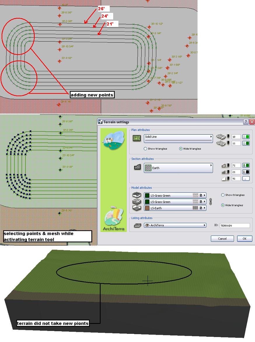
Use the plateaux tool to perform both the action:
1. sloped plateaux for the first issue
2. a "normal" plateaux (digging) to create the place where you want create the basin
BTW, what you are trying to do (selecting nodes and terrain and clicking on the terrain tool) is not described anywhre in the user manual...
Friendly
Fabrizio
1. sloped plateaux for the first issue
2. a "normal" plateaux (digging) to create the place where you want create the basin
BTW, what you are trying to do (selecting nodes and terrain and clicking on the terrain tool) is not described anywhre in the user manual...
Friendly
Fabrizio
Fabrizio Diodati
Graphisoft Italy Srl | Via Rossignago 2/A Spinea Venezia 30038 Italy
Graphisoft Italy Srl | Via Rossignago 2/A Spinea Venezia 30038 Italy
Still looking?
