
Turn on suggestions
Auto-suggest helps you quickly narrow down your search results by suggesting possible matches as you type.
Showing results for
EN
Turn on suggestions
Auto-suggest helps you quickly narrow down your search results by suggesting possible matches as you type.
Showing results for
Options
- Subscribe to RSS Feed
- Mark Topic as New
- Mark Topic as Read
- Pin this post for me
- Bookmark
- Subscribe to Topic
- Mute
- Printer Friendly Page
Anonymous
Not applicable
Options
- Mark as New
- Bookmark
- Subscribe
- Mute
- Subscribe to RSS Feed
- Permalink
- Report Inappropriate Content
2015-04-01 07:12 PM
NGVD with Story Levels
2015-04-01
07:12 PM

9 Replies 9
Community Admin
Options
- Mark as New
- Bookmark
- Subscribe
- Mute
- Subscribe to RSS Feed
- Permalink
- Report Inappropriate Content
2015-04-02 04:51 PM
2015-04-02
04:51 PM
I think this would only be possible by modifying the built-in Story Marker.
You can define a new Reference Level, name it N.V.G.D. Then in the Story Marker settings you can set the Reference Level parameter to this value. However, the Story Marker is currently scripted to display only one value above the Story line, you would have to modify the script so you can compose it from various values.
You can define a new Reference Level, name it N.V.G.D. Then in the Story Marker settings you can set the Reference Level parameter to this value. However, the Story Marker is currently scripted to display only one value above the Story line, you would have to modify the script so you can compose it from various values.
Loving Archicad since 1995 - Find Archicad Tips at x.com/laszlonagy
AMD Ryzen9 5900X CPU, 64 GB RAM 3600 MHz, Nvidia GTX 1060 6GB, 500 GB NVMe SSD
2x28" (2560x1440), Windows 10 PRO ENG, Ac20-Ac29
AMD Ryzen9 5900X CPU, 64 GB RAM 3600 MHz, Nvidia GTX 1060 6GB, 500 GB NVMe SSD
2x28" (2560x1440), Windows 10 PRO ENG, Ac20-Ac29
Anonymous
Not applicable
Options
- Mark as New
- Bookmark
- Subscribe
- Mute
- Subscribe to RSS Feed
- Permalink
- Report Inappropriate Content
2015-04-03 03:12 AM
2015-04-03
03:12 AM
Thanks.
David Maudlin
Rockstar
Options
- Mark as New
- Bookmark
- Subscribe
- Mute
- Subscribe to RSS Feed
- Permalink
- Report Inappropriate Content
2015-04-03 02:54 PM
2015-04-03
02:54 PM
Cheikh:
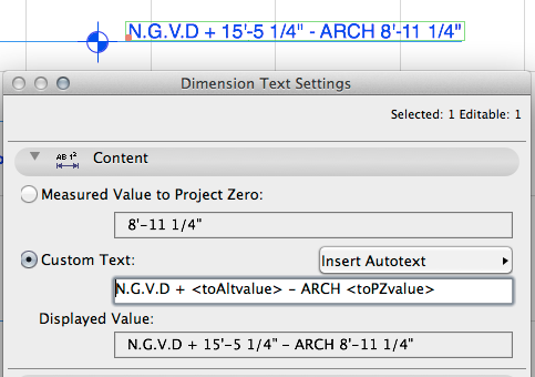
Another option is to use the Dimensioning Tool with the Elevation construction method, which allows multiple references in the marker text. But this is not automatic, you have to place dimensions to the model (I usually dimension to the floor slabs which follow the story heights).
David
Another option is to use the Dimensioning Tool with the Elevation construction method, which allows multiple references in the marker text. But this is not automatic, you have to place dimensions to the model (I usually dimension to the floor slabs which follow the story heights).
David
David Maudlin / Architect
www.davidmaudlin.com
Digital Architecture
AC29 USA Perpetual • Mac mini M4 Pro OSX15 | 64 gb ram • MacBook Pro M3 Pro OSX14 | 36 gb ram
www.davidmaudlin.com
Digital Architecture
AC29 USA Perpetual • Mac mini M4 Pro OSX15 | 64 gb ram • MacBook Pro M3 Pro OSX14 | 36 gb ram
RandyC
Advocate
Options
- Mark as New
- Bookmark
- Subscribe
- Mute
- Subscribe to RSS Feed
- Permalink
- Report Inappropriate Content
2015-04-03 04:29 PM
2015-04-03
04:29 PM
the elevation tool from Masterscript might help.
http://www.masterscript.nl/epages/78066077.sf/en_GB/?ObjectPath=/Shops/78066077/Products/33
ArchiCAD 4.5 --- 27 , Win 10 , dual monitors, 64 gb ram,Nvidia GeforceRTX 2080 TI, I-9
Anonymous
Not applicable
Options
- Mark as New
- Bookmark
- Subscribe
- Mute
- Subscribe to RSS Feed
- Permalink
- Report Inappropriate Content
2015-04-03 04:37 PM
2015-04-03
04:37 PM
David,
That is quite a neat tool. I saw it on some construction documents but did not know about it. I am wondering if the elevation dimensioning could be set to a datum value, but I assume that even if it could, it would affect the story markers as well. Thanks for the tip.
That is quite a neat tool. I saw it on some construction documents but did not know about it. I am wondering if the elevation dimensioning could be set to a datum value, but I assume that even if it could, it would affect the story markers as well. Thanks for the tip.
Anonymous
Not applicable
Options
- Mark as New
- Bookmark
- Subscribe
- Mute
- Subscribe to RSS Feed
- Permalink
- Report Inappropriate Content
2015-04-03 04:45 PM
2015-04-03
04:45 PM
Randy,
Thanks. That is a neat tool also. I will check it out.
Thanks. That is a neat tool also. I will check it out.
David Maudlin
Rockstar
Options
- Mark as New
- Bookmark
- Subscribe
- Mute
- Subscribe to RSS Feed
- Permalink
- Report Inappropriate Content
2015-04-04 03:42 PM
2015-04-04
03:42 PM
Cheikh wrote:The Dimension Tool allows more than one datum to be used, but will display the same Dimension setting (your example has both decimal feet and feet & inches). It also cannot have multiline text, so will not do everything in your illustration, but will show the correct datum when these values change.
I am wondering if the elevation dimensioning could be set to a datum value, but I assume that even if it could, it would affect the story markers as well.
David
David Maudlin / Architect
www.davidmaudlin.com
Digital Architecture
AC29 USA Perpetual • Mac mini M4 Pro OSX15 | 64 gb ram • MacBook Pro M3 Pro OSX14 | 36 gb ram
www.davidmaudlin.com
Digital Architecture
AC29 USA Perpetual • Mac mini M4 Pro OSX15 | 64 gb ram • MacBook Pro M3 Pro OSX14 | 36 gb ram
Anonymous
Not applicable
Options
- Mark as New
- Bookmark
- Subscribe
- Mute
- Subscribe to RSS Feed
- Permalink
- Report Inappropriate Content
2015-04-04 04:51 PM
2015-04-04
04:51 PM
David,
That is a great hidden dimensioning tool that gives me what I needed. Even if one has to enter the text info manually, once done it shows both elevations values. Thank again so much.
That is a great hidden dimensioning tool that gives me what I needed. Even if one has to enter the text info manually, once done it shows both elevations values. Thank again so much.
David Maudlin
Rockstar
Options
- Mark as New
- Bookmark
- Subscribe
- Mute
- Subscribe to RSS Feed
- Permalink
- Report Inappropriate Content
2015-04-05 01:56 PM
2015-04-05
01:56 PM
Cheikh:
Glad that that solution worked for you.
David
Glad that that solution worked for you.
David
David Maudlin / Architect
www.davidmaudlin.com
Digital Architecture
AC29 USA Perpetual • Mac mini M4 Pro OSX15 | 64 gb ram • MacBook Pro M3 Pro OSX14 | 36 gb ram
www.davidmaudlin.com
Digital Architecture
AC29 USA Perpetual • Mac mini M4 Pro OSX15 | 64 gb ram • MacBook Pro M3 Pro OSX14 | 36 gb ram
Still looking?
Suggested topics
- New Story Moves Whole Model in Modeling
- ArchiCAD to AutoCAD: Text in Level Dimensions Splitting into Two Lines (Fix) in Documentation
- Up/Down Text in the Stair tool in Modeling
- missing wall segments along the bottom of 1st story in Our Community
- Side-by-Side Modeling: Reusing Previous Projects as “Live” References Instead of template file in Project data & BIM
