
Turn on suggestions
Auto-suggest helps you quickly narrow down your search results by suggesting possible matches as you type.
Showing results for
EN
Turn on suggestions
Auto-suggest helps you quickly narrow down your search results by suggesting possible matches as you type.
Showing results for
Options
- Subscribe to RSS Feed
- Mark Topic as New
- Mark Topic as Read
- Pin this post for me
- Bookmark
- Subscribe to Topic
- Mute
- Printer Friendly Page
roxana_g
Participant
Options
- Mark as New
- Bookmark
- Subscribe
- Mute
- Subscribe to RSS Feed
- Permalink
- Report Inappropriate Content
2024-06-14 04:04 PM
World coordinates into local coordinates
2024-06-14
04:04 PM
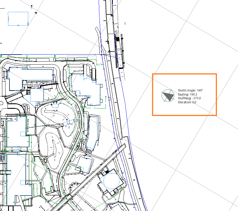
I am writing regarding one function that seems to be missing from the ArchiCAD software. There are a few countries, like Ireland, which use their coordinate system. In Ireland’s case, it’s called ITM.
Many of our consultants are still working in 2D, so they set up their ITM coordinates in AutoCAD. As we work in ArchiCAD, many times, we have to export our Site Layout Plan in dwg and overlap it in AutoCAD over the survey which is in the ITM coordinates. This is how we place our Site Layout Plan into ITM.
Is there a way to set up the ITM coordinates directly in ArchiCAD, so when we export dwgs these will be directly in the proper system? They expect when they open the dwg in Autocad everything to be set in the ITM.
Operating system used: Windows
2 Replies 2
Options
- Mark as New
- Bookmark
- Subscribe
- Mute
- Subscribe to RSS Feed
- Permalink
- Report Inappropriate Content
2024-06-17
02:04 PM
- last edited on
2024-06-19
03:18 PM
by
![]() Laszlo Nagy
Laszlo Nagy
2024-06-17
02:04 PM
Hello @roxana_g,
If ITM coordinates are X,Y,Z coordinates you have to place the localisation point at the ITM origin and modify the dwg export parameter about it.
And...

Sorry about the french interface. I do not find the right link on Graphisoft website.
Aaron Bourgoin
Rockstar
Options
- Mark as New
- Bookmark
- Subscribe
- Mute
- Subscribe to RSS Feed
- Permalink
- Report Inappropriate Content
2024-06-17 02:09 PM
2024-06-17
02:09 PM
I think this a huge gap in Archicad's interoperability space. Any Northing and Easting you might add to the Survey Point translates in an IFC, but not in a 2D DWG. There are still too many consultants working in that space to ignore this.
Think Like a Spec Writer
MacBook M4Pro - 24Gb RAM
AC4.55 through 29 / AC29.2.0 USA
Rhino 8.32 Mac
MacOS Tahoe 26.5.1
MacBook M4Pro - 24Gb RAM
AC4.55 through 29 / AC29.2.0 USA
Rhino 8.32 Mac
MacOS Tahoe 26.5.1
Still looking?
Suggested topics
- Importing DWG as external drawing wrong coordinates compared to XREF in Collaboration with other software
- Project origin error, intangible second project origin in 3D view in Modeling
- BEP hosting/sharing/coordination in Collaboration with other software
- Extract zone position from schedule in General discussions
- How to match AutoCAD drawing coordinates in Archicad? in Modeling
