Turn on suggestions
Auto-suggest helps you quickly narrow down your search results by suggesting possible matches as you type.
Showing results for
Turn on suggestions
Auto-suggest helps you quickly narrow down your search results by suggesting possible matches as you type.
Showing results for
2024 Technology Preview Program:
Master powerful new features and shape the latest BIM-enabled innovations
Installation & update
About program installation and update, hardware, operating systems, setup, etc.
- Graphisoft Community (INT)
- :
- Forum
- :
- Installation & update
- :
- Re: how to include contour lines inthe site mesh
Options
- Subscribe to RSS Feed
- Mark Topic as New
- Mark Topic as Read
- Pin this post for me
- Bookmark
- Subscribe to Topic
- Mute
- Printer Friendly Page
how to include contour lines inthe site mesh
Anonymous
Not applicable
Options
- Mark as New
- Bookmark
- Subscribe
- Mute
- Subscribe to RSS Feed
- Permalink
- Report Inappropriate Content
2006-04-25 10:36 AM
2006-04-25
10:36 AM
8 REPLIES 8
Anonymous
Not applicable
Options
- Mark as New
- Bookmark
- Subscribe
- Mute
- Subscribe to RSS Feed
- Permalink
- Report Inappropriate Content
2006-04-25 03:10 PM
2006-04-25
03:10 PM
The easiest way I have found is to draw (or trace) them with the spline tool and then use the magic wand (spacebar click) to apply them to the mesh (select the mesh and make the mesh tool active - the magic wand behavior depends on the current tool).
Anonymous
Not applicable
Options
- Mark as New
- Bookmark
- Subscribe
- Mute
- Subscribe to RSS Feed
- Permalink
- Report Inappropriate Content
2006-04-25 06:40 PM
2006-04-25
06:40 PM
If the Contour lines were originally created from a AutoCAD Data file you may want to look into Cigraphs ArchiTerra Plug-in. Info found here.
With this plug-in you can import the DXF file (contains the 3D point information that ArchiTerra reads) and you can generate that Mesh directly from the DXF data file.
Alternatively you can import a TXT file of the Points (AutoCAd can create a ASC file of the Survey data that can in turn be saved as a TXT file in say MS Excel. From the imported TXT data a mesh can be created. And from the ArchiTerra Mesh you can use a Tool that creates the Contour lines of your mesh as a Library part.
Options
- Mark as New
- Bookmark
- Subscribe
- Mute
- Subscribe to RSS Feed
- Permalink
- Report Inappropriate Content
2006-04-28 12:13 AM
2006-04-28
12:13 AM
In my opinion, Architerra will ONLY really help if you just have a table with the surveyor's data points in a text (or Excel) file.
If you've already got a contour map, it's better to use Matthew's method, very nicely explained in the Archiguide in this non-obvious tip, worth a bookmark. Archicad's help file isn't bad as well.
http://www.graphisoft.com/support/archicad/archiguide/surveyordrawings.html
If you've already got a contour map, it's better to use Matthew's method, very nicely explained in the Archiguide in this non-obvious tip, worth a bookmark. Archicad's help file isn't bad as well.
AC4.1-AC26SWE; MacOS13.5.1; MP5,1+MBP16,1
Anonymous
Not applicable
Options
- Mark as New
- Bookmark
- Subscribe
- Mute
- Subscribe to RSS Feed
- Permalink
- Report Inappropriate Content
2006-05-03 11:05 PM
2006-05-03
11:05 PM
To each his own...
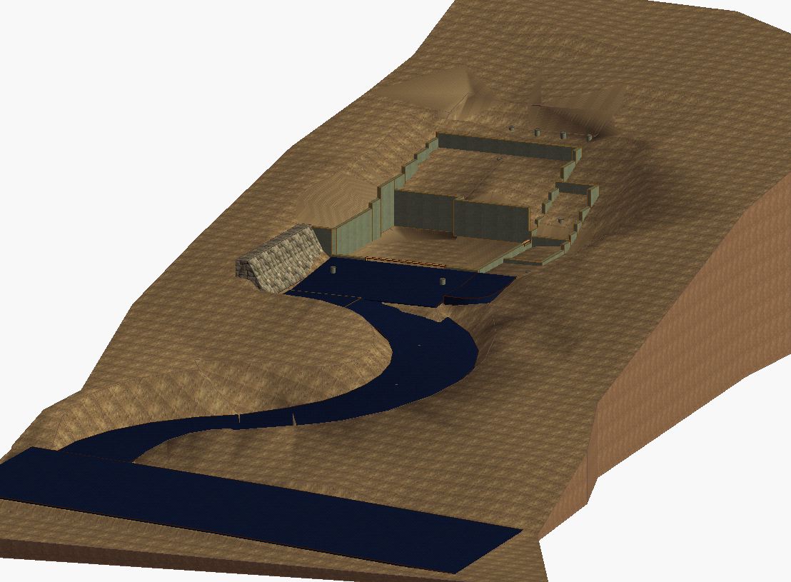
I have had good success working with the DXF file also. Except for yesterday... the DXF file that was sent to me did not have all the layers and therefore, not all the data points. The Surveyor did not include his the "Surface" layer in the DXF. He did not know my needs. I made a call to him and after a 5 minute discussion he E-mailed me a new DXF with only one layer and all the surface information. He said the layer contained what he called it a TIN data. It worked great. I had a Mesh within 15 Seconds of receiving the E-mail. And with the ArchTerra Tools I manipulated the site and added the Driveways. Attached is a JPG of a few projects.
I have had good success working with the DXF file also. Except for yesterday... the DXF file that was sent to me did not have all the layers and therefore, not all the data points. The Surveyor did not include his the "Surface" layer in the DXF. He did not know my needs. I made a call to him and after a 5 minute discussion he E-mailed me a new DXF with only one layer and all the surface information. He said the layer contained what he called it a TIN data. It worked great. I had a Mesh within 15 Seconds of receiving the E-mail. And with the ArchTerra Tools I manipulated the site and added the Driveways. Attached is a JPG of a few projects.
Anonymous
Not applicable
Options
- Mark as New
- Bookmark
- Subscribe
- Mute
- Subscribe to RSS Feed
- Permalink
- Report Inappropriate Content
2006-05-03 11:07 PM
Anonymous
Not applicable
Options
- Mark as New
- Bookmark
- Subscribe
- Mute
- Subscribe to RSS Feed
- Permalink
- Report Inappropriate Content
2006-05-03 11:20 PM
Anonymous
Not applicable
Options
- Mark as New
- Bookmark
- Subscribe
- Mute
- Subscribe to RSS Feed
- Permalink
- Report Inappropriate Content
2006-05-03 11:21 PM
Anonymous
Not applicable
Options
- Mark as New
- Bookmark
- Subscribe
- Mute
- Subscribe to RSS Feed
- Permalink
- Report Inappropriate Content
2006-05-03 11:22 PM
2006-05-03
11:22 PM
Same Site view as before using the Internal 3D Engine. Slower image but can better see the grade changes.


Related articles
- Project Zero, site model, and undecided finished floor level in Modeling
- Best value tool for modelling/manipulating terrain and for Landscape works and include contour lines in Collaboration with other software
- Modeling mesh with contours in Modeling
- how to include contour lines inthe site mesh in Installation & update
Still looking?
