
Turn on suggestions
Auto-suggest helps you quickly narrow down your search results by suggesting possible matches as you type.
Showing results for
EN
Turn on suggestions
Auto-suggest helps you quickly narrow down your search results by suggesting possible matches as you type.
Showing results for
Options
- Subscribe to RSS Feed
- Mark Topic as New
- Mark Topic as Read
- Pin this post for me
- Bookmark
- Subscribe to Topic
- Mute
- Printer Friendly Page
Anonymous
Not applicable
Options
- Mark as New
- Bookmark
- Subscribe
- Mute
- Subscribe to RSS Feed
- Permalink
- Report Inappropriate Content
2012-12-19
11:21 AM
- last edited on
2023-05-25
05:01 PM
by
![]() Rubia Torres
Rubia Torres
Using GPS Survey Data in Archi Cad
2012-12-19
11:21 AM
I have been working, and surveying land using the LEICA 1200 GPS, creating spot height drawings. I usually drag the drawing in to sketch up and work away, but since we recently bought ARCHI CAD16 and was wondering how/if it is possible to input the data and create a 3D mesh from the data. When I export the data from the GPS I can export to a DXF file. Is this the correct format, or has anybody had this problem before and knows how to help?
Regards
OrkneyCAD
5 Replies 5
David Maudlin
Rockstar
Options
- Mark as New
- Bookmark
- Subscribe
- Mute
- Subscribe to RSS Feed
- Permalink
- Report Inappropriate Content
2012-12-19 01:36 PM
2012-12-19
01:36 PM
OrkneyCAD:
If the GPS data can be formatted correctly, you could use the Place Mesh from Surveyors Data... command to import the data points as a Mesh. Here is one thread about this (you can search the forum for others):
Making mesh from map and text values (imported from dwg)
You should add a Signature to your Profile (click the Profile button near the top of this page) with your ArchiCAD version and operating system (see mine for an example) for more accurate help in this forum.
David
David Maudlin / Architect
www.davidmaudlin.com
Digital Architecture
AC29 USA Perpetual • Mac mini M4 Pro OSX15 | 64 gb ram • MacBook Pro M3 Pro OSX14 | 36 gb ram
www.davidmaudlin.com
Digital Architecture
AC29 USA Perpetual • Mac mini M4 Pro OSX15 | 64 gb ram • MacBook Pro M3 Pro OSX14 | 36 gb ram
Anonymous
Not applicable
Options
- Mark as New
- Bookmark
- Subscribe
- Mute
- Subscribe to RSS Feed
- Permalink
- Report Inappropriate Content
2013-01-04 04:41 PM
2013-01-04
04:41 PM
Is there a way to export mesh points or level dimensions in cogo , xml, or txt formats? I have imported surveyor data (from txt file) before and would like to know if it is possible to export new elevation points to give back to civil engineer
David Maudlin
Rockstar
Options
- Mark as New
- Bookmark
- Subscribe
- Mute
- Subscribe to RSS Feed
- Permalink
- Report Inappropriate Content
2013-01-05 09:19 PM
2013-01-05
09:19 PM
Meggz:
Not directly. But there is a way to extract the data points from the Mesh.
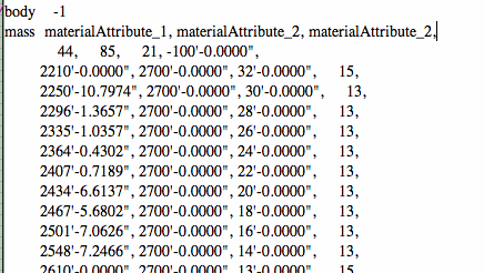
Select the Mesh then use the Object… command to covert the Mesh to an Object. Open this object using the Open Object… command. In the 3D Script of the object will be a MASS statement (around line 40), followed by 2 lines of mass parameters (materials, number of points etc, see MASS command in the GDL Reference Guide), and then one data point per line (x, y, z, status code). The x, y, z coordinates could be extracted from this script and reformatted for the surveyor’s use.
I don’t know if it is worth the effort, but could be useful if a set procedure was established then just redone as the Mesh changed.
David
Not directly. But there is a way to extract the data points from the Mesh.
Select the Mesh then use the Object… command to covert the Mesh to an Object. Open this object using the Open Object… command. In the 3D Script of the object will be a MASS statement (around line 40), followed by 2 lines of mass parameters (materials, number of points etc, see MASS command in the GDL Reference Guide), and then one data point per line (x, y, z, status code). The x, y, z coordinates could be extracted from this script and reformatted for the surveyor’s use.
I don’t know if it is worth the effort, but could be useful if a set procedure was established then just redone as the Mesh changed.
David
David Maudlin / Architect
www.davidmaudlin.com
Digital Architecture
AC29 USA Perpetual • Mac mini M4 Pro OSX15 | 64 gb ram • MacBook Pro M3 Pro OSX14 | 36 gb ram
www.davidmaudlin.com
Digital Architecture
AC29 USA Perpetual • Mac mini M4 Pro OSX15 | 64 gb ram • MacBook Pro M3 Pro OSX14 | 36 gb ram
Anonymous
Not applicable
Options
- Mark as New
- Bookmark
- Subscribe
- Mute
- Subscribe to RSS Feed
- Permalink
- Report Inappropriate Content
2013-01-07 04:35 PM
2013-01-07
04:35 PM
David Maudlin
Sorry for the delay in responding to your last post.
I am still trying to get the GPS formatted to the correct format so it can be imported to ArchiCAD. Your attached thread is very helpful as well.
I will get my Profile up to date as well, I am new to this forum so might take me a few mins to get totally up to speed.
Thanks
OrkneyCAD
Anonymous
Not applicable
Options
- Mark as New
- Bookmark
- Subscribe
- Mute
- Subscribe to RSS Feed
- Permalink
- Report Inappropriate Content
2013-01-15 01:47 PM
2013-01-15
01:47 PM
Sweet! Thanks, I've sent the saved out txt file to the engineer for import into Autodesk Civil 3D...will keep you posted
Still looking?
Suggested topics
- Creating HLA drawings for PHPP calcs in Sustainable design
- Importing DWG as external drawing wrong coordinates compared to XREF in Collaboration with other software
- Project origin error, intangible second project origin in 3D view in Modeling
- Mesh points only from poly lines / lines? in Modeling
- IFC export ignoring rotation and elevation of survey point in Collaboration with other software
