
Turn on suggestions
Auto-suggest helps you quickly narrow down your search results by suggesting possible matches as you type.
Showing results for
EN
Turn on suggestions
Auto-suggest helps you quickly narrow down your search results by suggesting possible matches as you type.
Showing results for
Options
- Subscribe to RSS Feed
- Mark Topic as New
- Mark Topic as Read
- Pin this post for me
- Bookmark
- Subscribe to Topic
- Mute
- Printer Friendly Page
Tom Krowka
Enthusiast
Options
- Mark as New
- Bookmark
- Subscribe
- Mute
- Subscribe to RSS Feed
- Permalink
- Report Inappropriate Content
2008-12-10
07:59 PM
- last edited on
2023-05-25
05:09 PM
by
![]() Rubia Torres
Rubia Torres
Mesh over site plan
2008-12-10
07:59 PM
24 Replies 24
Anonymous
Not applicable
Options
- Mark as New
- Bookmark
- Subscribe
- Mute
- Subscribe to RSS Feed
- Permalink
- Report Inappropriate Content
2008-12-10 11:41 PM
2008-12-10
11:41 PM
make a mesh of the boundary shape
then space click the contour lines with the mesh tool on
hit "fit to user ridges" each time the dialog box come up as you do this
then with the mesh selected click each of the contour lines and change the Z values to suit (tick the "apply to all " box each time)
then set the heights for the corners to suit.
Anonymous
Not applicable
Options
- Mark as New
- Bookmark
- Subscribe
- Mute
- Subscribe to RSS Feed
- Permalink
- Report Inappropriate Content
2008-12-10 11:43 PM
2008-12-10
11:43 PM
theres a detailed how to here under "tips and tricks"
u might need to redgister on the site to view it tho
http://archicadselect.com/
u might need to redgister on the site to view it tho
http://archicadselect.com/
Tom Krowka
Enthusiast
Options
- Mark as New
- Bookmark
- Subscribe
- Mute
- Subscribe to RSS Feed
- Permalink
- Report Inappropriate Content
2008-12-12 10:32 PM
2008-12-12
10:32 PM
Would that be "quick tip 2006#2, Stamping meshes". That seems to be the only one I can find that relates at all to this process.
Tried your short method.....doesn't seem to work quite the same. Do the contour lines have to be contained within the mesh boundary?
Tried your short method.....doesn't seem to work quite the same. Do the contour lines have to be contained within the mesh boundary?
Thomas Holm
Enthusiast
Options
- Mark as New
- Bookmark
- Subscribe
- Mute
- Subscribe to RSS Feed
- Permalink
- Report Inappropriate Content
2008-12-12 10:51 PM
2008-12-12
10:51 PM
AC4.1-AC26SWE; MacOS13.5.1; MP5,1+MBP16,1
Karl Ottenstein
Moderator Emeritus
Options
- Mark as New
- Bookmark
- Subscribe
- Mute
- Subscribe to RSS Feed
- Permalink
- Report Inappropriate Content
2008-12-13 01:06 AM
2008-12-13
01:06 AM
GeNOS wrote:Tom,
make a mesh of the boundary shape
then space click the contour lines with the mesh tool on
I have yet to encounter a survey dwg in the US (Tom's question) that allows magic wanding of the contours because of (1) the major contours are not continuous - breaks for in-line elevation annotation and (2) the contours have way too many points, and magic wanding adds all of that unnecessary data to the mesh, adding too many polygons.
In my experience, tracing over the contours (snapping at reasonable points) is fastest and gives the 'fastest' (low polygon) mesh. I'd trace pretty precisely and include minor contours at the actual building site in your 5 acre parcel - and do just major contours and somewhat looser contour hugging for the rest of the lot.
Generally, I trace over with polylines and then magic wand them (again, because I have yet to receive continous surveyor contours).
Sounds like in the lands down under they get better files than I've seen here...
Karl
PS The article that Thomas links to is useful for magic wand settings, etc.
Vote for Wish: Copy/Paste in 3D
AC 29 USA and earlier • hardware key • macOS Tahoe 26.5.2 MacBook Pro M2 Max 12CPU/30GPU cores, 32GB
AC 29 USA and earlier • hardware key • macOS Tahoe 26.5.2 MacBook Pro M2 Max 12CPU/30GPU cores, 32GB
Karl Ottenstein
Moderator Emeritus
Options
- Mark as New
- Bookmark
- Subscribe
- Mute
- Subscribe to RSS Feed
- Permalink
- Report Inappropriate Content
2008-12-13 01:14 AM
2008-12-13
01:14 AM
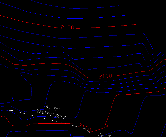
I see Roberto's Italian survey had continuous contour lines as well... so I'm posting what I have found to be typical, at least in the mountain west of the US. Notice that the major contours (red) are broken to display the elevation text inline. This is not a masking thing. There really is no line there - so you have to recreate a continuous contour that spans the text to get the mesh ridge entered properly.
Is this what other people in the US see as well? I've assumed this is how all US Civils are trained...but maybe it is a local thing...
Cheers,
Karl
Is this what other people in the US see as well? I've assumed this is how all US Civils are trained...but maybe it is a local thing...
Cheers,
Karl
Vote for Wish: Copy/Paste in 3D
AC 29 USA and earlier • hardware key • macOS Tahoe 26.5.2 MacBook Pro M2 Max 12CPU/30GPU cores, 32GB
AC 29 USA and earlier • hardware key • macOS Tahoe 26.5.2 MacBook Pro M2 Max 12CPU/30GPU cores, 32GB
vfrontiers
Advocate
Options
- Mark as New
- Bookmark
- Subscribe
- Mute
- Subscribe to RSS Feed
- Permalink
- Report Inappropriate Content
2008-12-13 01:51 AM
2008-12-13
01:51 AM
Same here Karl.... It's a bummer to have to FILL IN these little lines.
Duane
Visual Frontiers
AC3.14 - AC29
:|: Enscape4.16:|:TwinMotion
DellXPS 4.7ghz i7:|: 8gb GPU 1070ti / Alienware M18 Laptop
Visual Frontiers
AC3.14 - AC29
:|: Enscape4.16:|:TwinMotion
DellXPS 4.7ghz i7:|: 8gb GPU 1070ti / Alienware M18 Laptop
Anonymous
Not applicable
Options
- Mark as New
- Bookmark
- Subscribe
- Mute
- Subscribe to RSS Feed
- Permalink
- Report Inappropriate Content
2008-12-13 01:53 AM
2008-12-13
01:53 AM
Hello Karl,
This is what I have seen here in the Northeast.
I understand that many surveyors use the same
cad application to produce their site survey drawings
as a DXF or a DWG file.
I don't remember if the last hand drawn survey I saw
used this convention but I have seen survey drawings
done by architects that had no break in the contour line
and the elevation text was only at the ends of the contour line.
Peter Devlin
Dwight
Newcomer
Options
- Mark as New
- Bookmark
- Subscribe
- Mute
- Subscribe to RSS Feed
- Permalink
- Report Inappropriate Content
2008-12-13 02:10 AM
2008-12-13
02:10 AM
The key is that the Archicad operator must, as Karl observes, cleverly build the mesh from extrapolated contours to minimize polygons in unimportant areas and carefully place nodes in critical areas to best model the true slope.
A blind reliance on tracing the contour plan guarantees an excessively high polygon count and creation of artificial horizontality in a situation that does not possess it.
A blind reliance on tracing the contour plan guarantees an excessively high polygon count and creation of artificial horizontality in a situation that does not possess it.
Dwight Atkinson
Still looking?
