Turn on suggestions
Auto-suggest helps you quickly narrow down your search results by suggesting possible matches as you type.
Showing results for
Turn on suggestions
Auto-suggest helps you quickly narrow down your search results by suggesting possible matches as you type.
Showing results for
2024 Technology Preview Program
2024 Technology Preview Program:
Master powerful new features and shape the latest BIM-enabled innovations
Modeling
About Archicad's design tools, element connections, modeling concepts, etc.
- Graphisoft Community (INT)
- :
- Forum
- :
- Modeling
- :
- Small Elevation Question
Options
- Subscribe to RSS Feed
- Mark Topic as New
- Mark Topic as Read
- Pin this post for me
- Bookmark
- Subscribe to Topic
- Mute
- Printer Friendly Page
Small Elevation Question
Anonymous
Not applicable
Options
- Mark as New
- Bookmark
- Subscribe
- Mute
- Subscribe to RSS Feed
- Permalink
- Report Inappropriate Content
2016-02-04
08:26 PM
- last edited on
2023-05-25
04:57 PM
by
![]() Rubia Torres
Rubia Torres
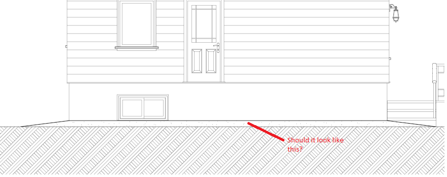
I was wondering, is this how it things should end up looking like in elevation view, or is there another way around? Where is the setting that controls the fill in the diagram, I can't seem to find it.
Thanks for helping out!
5 REPLIES 5
Anonymous
Not applicable
Options
- Mark as New
- Bookmark
- Subscribe
- Mute
- Subscribe to RSS Feed
- Permalink
- Report Inappropriate Content
2016-02-04 09:01 PM
alexwang32 wrote:Correct me if I am wrong but is the fill Earth with a grass top on it? That's what it looks like.
I'm modeling the sloped grade around the house, I did so by adding four mesh points ( it's a rectangular house ) and elevating them. However, what I get in the elevation view looks rather confusing at first glance. The sloped part doesn't have the same fill... and there's a separation line.
I was wondering, is this how it things should end up looking like in elevation view, or is there another way around? Where is the setting that controls the fill in the diagram, I can't seem to find it.
Thanks for helping out!
Anonymous
Not applicable
Options
- Mark as New
- Bookmark
- Subscribe
- Mute
- Subscribe to RSS Feed
- Permalink
- Report Inappropriate Content
2016-02-04 09:25 PM
Ah yes you're right... totally forgot about the vectorial hatching of the grass. 
I deselected the 'override surface' and the Earth Hatching came out, looking like this.
As you can see the hatching has adapted to the slope of the mesh and is distorted. Does this look correct? Because I'm not sure if it's the way engineers and architects draw it. I've seen the grade in hand drawn elevations but they usually don't look like that...
Options
- Mark as New
- Bookmark
- Subscribe
- Mute
- Subscribe to RSS Feed
- Permalink
- Report Inappropriate Content
2016-02-05 02:44 PM
alexwang32:
What you are getting is an accurate image of the model: the elevation cut line (where the Elevation Line is placed in plan) cuts the Mesh, and the grade slopes up from there to the wall of the house (as it should). This is how elevations look in my documents, it has never been an issue. If you wanted to have the grade cut at the house wall you have a few options:
1. Move the Elevation Line to the face of the Wall, but then the model will cut any elements beyond the Wall, like eaves, which are not typically cut.
2. Add a Fill that matches the Mesh fill to cover the sloping grade to wall, this will need to be adjusted separately if the grade changes.
David
David Maudlin / Architect
www.davidmaudlin.com
Digital Architecture
AC27 USA • iMac 27" 4.0GHz Quad-core i7 OSX11 | 24 gb ram • MacBook Pro M3 Pro | 36 gb ram OSX14
www.davidmaudlin.com
Digital Architecture
AC27 USA • iMac 27" 4.0GHz Quad-core i7 OSX11 | 24 gb ram • MacBook Pro M3 Pro | 36 gb ram OSX14
Anonymous
Not applicable
Options
- Mark as New
- Bookmark
- Subscribe
- Mute
- Subscribe to RSS Feed
- Permalink
- Report Inappropriate Content
2016-02-05 04:11 PM
Thanks David, good to know. I'll see what turns out better.
If I choose to present a uniform fill for the mesh around the house for clarity purpose then I'll probably do as you said 2) and simply put a fill to cover it up ( I'll have to do this in 4 elevations ), since I don't want the roof to get messed up, that'll be more of a hassle.
If I choose to present a uniform fill for the mesh around the house for clarity purpose then I'll probably do as you said 2) and simply put a fill to cover it up ( I'll have to do this in 4 elevations ), since I don't want the roof to get messed up, that'll be more of a hassle.
Options
- Mark as New
- Bookmark
- Subscribe
- Mute
- Subscribe to RSS Feed
- Permalink
- Report Inappropriate Content
2016-02-05 04:16 PM
You could relocate to the Netherlands, specifically the west, where things are nice and flat  We draw most our terrain with the slab tool!
3rd suggestion, make a terrain only section/elevation. So special layercombo only showing terrain and special section/elevation that cuts the terrain where you want it. Overlay that view on your layout sheet.
That keeps things 'live', rather than 2d patchwork, which might require re-doing once you are landscaping the terrain mesh.
Erwin Edel, Project Lead, Leloup Architecten
www.leloup.nl
ArchiCAD 9-26NED FULL
Windows 10 Pro
Adobe Design Premium CS5
www.leloup.nl
ArchiCAD 9-26NED FULL
Windows 10 Pro
Adobe Design Premium CS5

Related articles
- IFC model exchange workflow - how to collaborate with engineers? in Collaboration with other software
- Project Zero, Sea Level, and Floor Level settings in Documentation
- Interior elevation bug – wrong pen on bordering elements in Documentation
- Audit/Check Solid Element Operations in Wishes
- Curtain wall is excluded from Drag command using marquee in Modeling
Still looking?
